NEBRASKA INTERACTIVE FIELD MAP
Inspect places, geology, access evidence and nearby context
The map keeps collecting leads, protected places and research occurrences visually distinct.
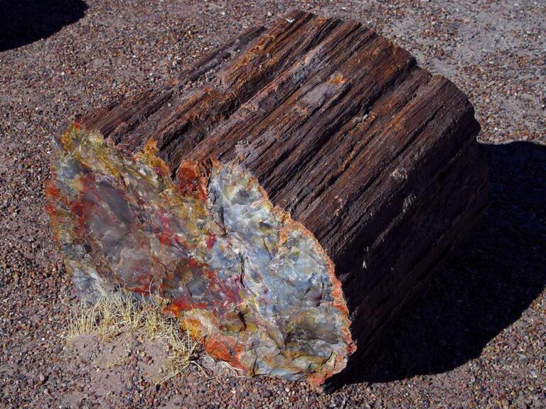
Rock and mineral reference images for Nebraska
These are real reference photographs from the site media library, not photographs of the exact mapped sites. Always confirm mineral identity and collection permissions separately.


TRIP-READY SHORTLIST
Best-supported rockhounding sites in Nebraska
This ranking favors current evidence, usable coordinates, navigation context and field readiness. It is not a popularity ranking and Conditional records still require verification.
Camp A Way — Gem Mining Waterfall Sluice
minerals, fossils, shark teeth and managed mining rough
The Archway — Archway Mining Company
fossils, minerals and rough gemstones in purchased mining rough
M&M Fossil Digs — Sept. 21–25, 2026 Private Ranch Access
Oligocene/Eocene vertebrate fossils on private ranch
The Mining House — Classic Traveling Claim
gems, fossils and minerals in operator-provided mining bags
The Mining House — Signature Traveling Claim + Geode
gems, fossils, minerals and one managed geode
BLM Nebraska Public Lands — Casual Rock / Mineral Collection Context
common rocks, mineral specimens, petrified wood and common fossil context
Nebraska National Forests & Grasslands — Surface Rock / Agate Collection Context
rocks and agates for personal hobby use
Nebraska Private Mine / Quarry / Ranch Field Trips
agates, fossils, gypsum, chalcedony, aggregate and industrial minerals
Nebraska River / Gravel-Bar Rockhounding Context
agates, jasper, petrified wood, quartz, gravel and fossil context
Schramm Park SRA — Geological Outcrop Fossil Discovery
Pennsylvanian marine fossils in limestone/shale outcrop
NEBRASKA MINERAL DISCOVERY
What can you find rockhounding in Nebraska?
The atlas mixes visitor programs, stronger collecting leads, protected environments and geological research. Material record counts are not promises that collecting is allowed. Verify the exact location and manager before taking anything.
Identify Nebraska rocks, minerals and fossils →
Agates & Chalcedony
18 recordsAgate-bearing gravels are associated with the western High Plains and transported deposits; precise public access is limited and variable.
Petrified Wood
7 recordsFossil wood in Nebraska sedimentary contexts is primarily an identification and research interest unless collecting authorization is confirmed.
Ashfall, Miocene & Vertebrate Fossils
36 recordsAshfall Fossil Beds and national fossil monuments preserve irreplaceable specimens; protected areas are not collecting sites.
Jasper, Chert & Flint
6 recordsSiliceous pebbles and regional bedrock fragments are widespread. Archaeological stone artifacts are cultural resources, not rockhounding targets.
Limestone, Calcite & Geodes
4 recordsEastern Nebraska limestone and quarried rock provide carbonate geology, but current quarry access and land use matter.
Quartz & Glacial Gravel
27 recordsGlacial deposits and river gravels contain transported quartz and other durable stones.
Gypsum & Sedimentary Minerals
2 recordsEvaporitic and sedimentary minerals can occur in western outcrops; test softness and natural cleavage.
Badlands Concretions & Ironstone
3 recordsWind-eroded sedimentary forms can create fossil-like concretions; avoid damaging fragile geologic features.
LAND, CLAIMS & PERMISSION
Who controls the land matters more than the mineral pin
The state map’s land-status and claim layers are planning aids. Exact ownership, claims, protected-resource rules and current manager guidance still control field use.
National monuments & fossil beds
Agate Fossil Beds and Scotts Bluff protect natural resources; fossil removal is prohibited without lawful authority.
Ashfall Fossil Beds
Scientific preservation and public viewing are the attraction; do not excavate or remove fossils.
National Forest/grassland rules
Toadstool and other federal sites have specific surface, fossil and cultural-resource rules; confirm with land managers.
Private agricultural land
Farm and ranch ownership determines access across many gravel and badlands localities.
Lake and river access
Reservoir and stream permissions differ; safety, water levels and habitat restrictions require checks.
WHEN TO GO
Nebraska rockhounding seasonal planner
Winter geology planning
Snow, ice and high winds reduce Badlands and gravel access.
Spring river and gravel season
Runoff, mud and fast weather changes constrain riverbanks.
Summer fossil-viewing season
Heat, storms, sun exposure and visitor crowds affect outdoor research.
Fall field observations
Cooler dry days favor western geology viewing; early snow is possible.
NEBRASKA FIELD KIT
A practical field kit for Nebraska
Match equipment to the site and collecting method rather than carrying heavy tools by default.
Identification kit
Hand lens, magnet, notebook, scale, specimen bags and labels help preserve context and reduce guesswork.
River / gravel kit
Use sturdy footwear, gloves and eye protection. Check water level, access and disturbance rules before entering a stream or shoreline.
Geode / hard-rock kit
Eye protection and small hand tools are more useful than heavy equipment. Never enter mine workings or unstable cuts.
Fossil kit
Camera, scale, notebook and protective wrapping allow documentation without assuming removal is legal.
Panning kit
A basic pan, classifier and vial are enough for many recreational contexts; powered equipment can trigger different rules.
Navigation & safety
Carry offline mapping, water, weather layers and an emergency plan appropriate to remoteness and season.
COMMUNITY FIELD INTELLIGENCE
Recent Nebraska field reports
Approved visitor reports add current observations without automatically changing a location’s legal or access status.
Open any location guide and use Share Your Story & Photos. Reports remain pending until admin approval.
EXPLORE NEBRASKA LOCALLY
Rockhounding near Nebraska cities
Move from statewide discovery into nearby field regions and then into individual location guides. City pages rank nearby records by evidence status and distance instead of treating every geological occurrence as an open collecting site.
Nebraska rockhounding regions and local areas
Regional pages group related geology and field opportunities without turning every mineral occurrence into a separate destination page.
Nebraska location directory preview
Start with the current inventory, then open the complete searchable directory for all 248 records.
Adams County — Geology & Rockhounding Research Context
county geology, mineral occurrences, surficial/bedrock context and mapped resources · Adams
Ashfall Fossil Beds Resource Firewall
fossils and other specimens · Antelope
Ashfall Fossil Beds State Historical Park — Fossils / Specimens Protected
Miocene vertebrate fossils, volcanic ash and other specimens · Antelope
Antelope County — Geology & Rockhounding Research Context
county geology, mineral occurrences, surficial/bedrock context and mapped resources · Antelope
Arthur County — Geology & Rockhounding Research Context
county geology, mineral occurrences, surficial/bedrock context and mapped resources · Arthur
Banner County — Geology & Rockhounding Research Context
county geology, mineral occurrences, surficial/bedrock context and mapped resources · Banner
Blaine County — Geology & Rockhounding Research Context
county geology, mineral occurrences, surficial/bedrock context and mapped resources · Blaine
Boone County — Geology & Rockhounding Research Context
county geology, mineral occurrences, surficial/bedrock context and mapped resources · Boone
Box Butte County — Geology & Rockhounding Research Context
county geology, mineral occurrences, surficial/bedrock context and mapped resources · Box Butte
Boyd County — Geology & Rockhounding Research Context
county geology, mineral occurrences, surficial/bedrock context and mapped resources · Boyd
Brown County — Geology & Rockhounding Research Context
county geology, mineral occurrences, surficial/bedrock context and mapped resources · Brown
The Archway — Archway Mining Company
fossils, minerals and rough gemstones in purchased mining rough · Buffalo
Buffalo County — Geology & Rockhounding Research Context
county geology, mineral occurrences, surficial/bedrock context and mapped resources · Buffalo
Managed Program Non-Bleed Gate
paid mining/fossil activity material · Buffalo / Lancaster / Douglas / Sioux
Burt County — Geology & Rockhounding Research Context
county geology, mineral occurrences, surficial/bedrock context and mapped resources · Burt
Butler County — Geology & Rockhounding Research Context
county geology, mineral occurrences, surficial/bedrock context and mapped resources · Butler
Cass County — Geology & Rockhounding Research Context
county geology, mineral occurrences, surficial/bedrock context and mapped resources · Cass
Weeping Water Limestone / Quarry District Research
limestone, calcite and quarry geology · Cass
Cedar County — Geology & Rockhounding Research Context
county geology, mineral occurrences, surficial/bedrock context and mapped resources · Cedar
Chase County — Geology & Rockhounding Research Context
county geology, mineral occurrences, surficial/bedrock context and mapped resources · Chase
Cherry County — Geology & Rockhounding Research Context
county geology, mineral occurrences, surficial/bedrock context and mapped resources · Cherry
Nebraska Sand Hills Geology Research
eolian sand, Ogallala substrate and groundwater-related geology · Cherry / Brown / Rock / Blaine / Thomas / Hooker / Grant / Arthur / McPherson
Cheyenne County — Geology & Rockhounding Research Context
county geology, mineral occurrences, surficial/bedrock context and mapped resources · Cheyenne
Clay County — Geology & Rockhounding Research Context
county geology, mineral occurrences, surficial/bedrock context and mapped resources · Clay
Nebraska: fossil viewing is not the same as fossil collecting
Nebraska preserves exceptional mammal fossil deposits, White River Group badlands, river gravels, calcareous formations and Pine Ridge rock exposures. Its state map includes many county or formation-level research records that should not be mistaken for legal places to excavate. Determine whether your interest is a museum-style fossil experience, an accessible managed visitor activity or permitted collecting on a specific land unit.
Ashfall Fossil Beds and Agate Fossil Beds National Monument
Ashfall Fossil Beds is an active paleontological research site; visitors cannot collect fossils or other specimens from the park. Its official visitor information reports the 2026 season has ended, with reopening planned for spring 2027. Agate Fossil Beds National Monument protects rocks, minerals and fossils, with collection limited to separately authorized scientific or special-use activities. Its Daemonelix and Fossil Hills formations require staying clear of unstable restricted slopes.
Toadstool and Pine Ridge landscape research
Toadstool’s sculpted badlands expose layered sediments and erosion patterns. The Toadstool guide is for studying geology and checking forest rules, not a promise of accessible petrified wood or vertebrate fossils. Pine Ridge agate and jasper records likewise remain research leads until precise land rights and collectable material classes are established.
Platte River gravels and private quarries
River-pebble assemblages can include quartz, chert, jasper and igneous rocks transported from distant sources. Before entering a river bar, determine the access route, flood stage, adjoining ownership and material-removal rights. Private ranch and quarry trips require affirmative owner/operator authorization. A guided fossil event listed for September 2026 is historical, not an upcoming reservation. For identification, use the Nebraska rock and fossil guide.