NEVADA INTERACTIVE FIELD MAP
Inspect places, geology, access evidence and nearby context
The map keeps collecting leads, protected places and research occurrences visually distinct.
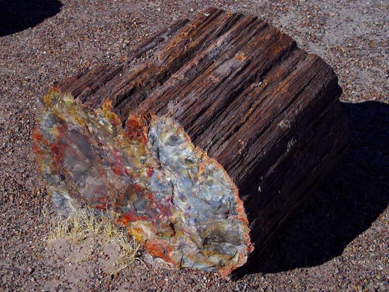
Rock and mineral reference images for Nevada
These are real reference photographs from the site media library, not photographs of the exact mapped sites. Always confirm mineral identity and collection permissions separately.



TRIP-READY SHORTLIST
Best-supported rockhounding sites in Nevada
This ranking favors current evidence, usable coordinates, navigation context and field readiness. It is not a popularity ranking and Conditional records still require verification.
Garnet Hill
garnet crystals in rhyolite
Oak Springs Trilobite Site Access Point
Common trilobite fossils
NEVADA MINERAL DISCOVERY
What can you find rockhounding in Nevada?
The atlas mixes visitor programs, stronger collecting leads, protected environments and geological research. Material record counts are not promises that collecting is allowed. Verify the exact location and manager before taking anything.
Identify Nevada rocks, minerals and fossils →
Virgin Valley Opals
4 recordsPrecious-opal sites are frequently operator-managed and private. Treat commercial mine listings as arrival or research context until current public access is confirmed.
Garnets & Ely Garnet Hill
3 recordsThe Garnet Hill public rockhound area is a distinct managed example; confirm boundaries and current posted instructions.
Agates, Jasper & Chalcedony
0 recordsDesert washes and volcanic rocks can contain silica specimens; geology records alone never verify land access.
No strong examples are currently surfaced for this material.
Turquoise & Historic Copper Mines
56 recordsTurquoise districts usually involve active/private mines and claims. Do not collect from spoil or workings without permission.
Quartz Crystals & Geodes
1 recordsSilica veins and volcanics expose quartz and related minerals on mixed public and private land.
Trilobite & Ancient Marine Fossils
8 recordsBLM/NPS and vertebrate fossil rules differ; casual common-invertebrate collecting may be possible only on eligible designated land.
Petrified Wood
0 recordsBLM Nevada describes a daily petrified-wood maximum of 25 pounds plus one piece and an annual 250-pound limit on eligible parcels.
No strong examples are currently surfaced for this material.
Obsidian, Rhyolite & Volcanic Rocks
4 recordsVolcanic rock and cultural-site associations require special care; never remove archaeological artifacts.
LAND, CLAIMS & PERMISSION
Who controls the land matters more than the mineral pin
The state map’s land-status and claim layers are planning aids. Exact ownership, claims, protected-resource rules and current manager guidance still control field use.
BLM noncommercial hand collection
BLM Nevada allows modest common mineral specimens using hand tools for personal use where not restricted by claims, mineral ownership, special areas or local orders.
Petrified wood quantity limits
BLM Nevada guidance states up to 25 pounds plus one piece daily and no more than 250 pounds yearly on eligible public lands.
Private opal mines and claims
Opal and turquoise fame does not grant collecting rights; verify operator availability, claim boundaries and visitor requirements.
Protected and tribal areas
Red Rock, historic cultural sites, monuments, reservations and archaeological features can be fully closed to rock removal.
Desert and mine safety
Carry offline navigation and water; avoid unstable shafts, heat, flash floods and unmaintained roads.
WHEN TO GO
Nevada rockhounding seasonal planner
Lower desert field checks
High-elevation snow and cold nights limit opal and Great Basin routes.
Good Basin field season
Moderate weather with muddy roads and variable mine operations.
Hot desert and high country
Heat and flash flooding constrain southern outings; plan early and verify hours.
Autumn collecting
Cooler conditions but early high-elevation snow closes remote tracks.
NEVADA FIELD KIT
A practical field kit for Nevada
Match equipment to the site and collecting method rather than carrying heavy tools by default.
Identification kit
Hand lens, magnet, notebook, scale, specimen bags and labels help preserve context and reduce guesswork.
River / gravel kit
Use sturdy footwear, gloves and eye protection. Check water level, access and disturbance rules before entering a stream or shoreline.
Geode / hard-rock kit
Eye protection and small hand tools are more useful than heavy equipment. Never enter mine workings or unstable cuts.
Fossil kit
Camera, scale, notebook and protective wrapping allow documentation without assuming removal is legal.
Panning kit
A basic pan, classifier and vial are enough for many recreational contexts; powered equipment can trigger different rules.
Navigation & safety
Carry offline mapping, water, weather layers and an emergency plan appropriate to remoteness and season.
COMMUNITY FIELD INTELLIGENCE
Recent Nevada field reports
Approved visitor reports add current observations without automatically changing a location’s legal or access status.
Open any location guide and use Share Your Story & Photos. Reports remain pending until admin approval.
EXPLORE NEVADA LOCALLY
Rockhounding near Nevada cities
Move from statewide discovery into nearby field regions and then into individual location guides. City pages rank nearby records by evidence status and distance instead of treating every geological occurrence as an open collecting site.
Nevada rockhounding regions and local areas
Regional pages group related geology and field opportunities without turning every mineral occurrence into a separate destination page.
Nevada location directory preview
Start with the current inventory, then open the complete searchable directory for all 251 records.
Clayton Valley Cinder Cone NBMG Research Point
Basalt/scoria geology · Esmeralda
Monte Cristo Range NBMG Research Point
Volcanic/sedimentary geology · Esmeralda
Bonanza Opal Mine Commercial Arrival Reference
Virgin Valley opal · Humboldt
Rainbow Ridge Opal Mine Commercial Arrival Reference
Precious opal · Humboldt
Royal Peacock Opal Mine Commercial Arrival Reference
Black fire opal · Humboldt
Oak Springs Trilobite Site Access Point
Common trilobite fossils · Lincoln
Big Rocks North Access Reference Point
Navigation / Big Rocks Wilderness trail access · Lincoln
Project Faultless NBMG Hazard Context Point
Geology/hazard context · Nye
Black Rock Lava Flow BLM Reference Point
Lava-flow geology · Nye
Easy Chair Crater NBMG Geology Reference Point
Volcanic geology · Nye
Lunar Crater BLM Reference Point
Volcanic geology · Nye
Tybo Town Arrival Reference Point
NONE_NAVIGATION_ONLY · Nye
Otteson Brothers Turquoise Controlled Location Reference
Turquoise · Nye / Esmeralda
McClellan Peak Basalt NBMG Research Point
Basalt geology · Washoe
Moon Rocks NBMG Geology Reference Point
Granite/mineral geology · Washoe
Ventifact Ridge NBMG Geology Reference Point
Welded tuff / sanidine · Washoe
Warm Springs Dike Swarm Hungry Valley Route Waypoint
Igneous geology access context · Washoe
Garnet Hill
garnet crystals in rhyolite · White Pine
Prince Mine
Manganese, Silver, Lead, Zinc, Vanadium, Copper, Arsenic
Republic Mine
Lead, Gold, Silver, Zinc, Copper, Vanadium
Ninety-Nine Mine
Copper, Lead, Silver, Gold, Vanadium
Pauline Mine
Lead, Zinc, Copper
Contact Mine
Zinc, Silver, Lead, Vanadium
Prairie Flower Mine
Zinc, Lead, Copper, Silver, Gold
Nevada field planning: opal claims, trilobites and public-land minerals
Many Nevada mineral sites are on federal lands, but that does not make every location open for collecting. The BLM generally allows reasonable noncommercial hobby rock collecting on eligible, unclaimed lands using hand tools and minimal disturbance. Existing mining claims, developed recreation sites, private mineral interests, wilderness restrictions, archaeological protections and the specific fossil class can change the answer completely.
Virgin Valley opals: enter through an authorized mine operator
The Royal Peacock, Bonanza and Rainbow Ridge guide pages are commercial-arrival references, not grants of access to surrounding mineral claims. Ask each operator for season, reservations, digging zones, fees, equipment and take-home policies. Opal deposits often require careful storage and handling; some hydrophane or high-water-content specimens may crack if dried too quickly.
Oak Springs trilobites: know the fossil category
The Oak Springs guide is a specific research or access reference. BLM allows limited personal collecting of common invertebrate fossils where not restricted, but vertebrate fossils and unusual scientifically significant material need permits and must not be treated as hobby specimens. Confirm the designated collecting area, trail or route and current office rules.
Garnet Hill and missing detailed guide coverage
BLM identifies Garnet Hill near Ely as a designated rockhounding area where garnets occur in volcanic rock. The current Nevada atlas does not yet provide a dedicated Garnet Hill location guide in this state’s detailed-page listing. The absence of a guide should not be filled by inventing an exact pin; verify BLM access directions and current land status before visiting. The same separation of geologic context and travel certainty applies to Warm Springs research waypoints.
Limits and hazards: BLM Nevada lists casual petrified-wood collection as up to 25 pounds plus one piece daily, with a 250-pound annual maximum. These are petrified-wood limits, not universal limits on all minerals. Carry sufficient water, check 4WD access and heat exposure, and do not drive onto active claims. Consult the Nevada mineral identification guide.