OREGON INTERACTIVE FIELD MAP
Where should you look for sunstones, agates and obsidian in Oregon?
The Oregon Sunstone Public Collection Area has marked BLM boundaries, with private claims nearby that require permission. For agates, use the named coastal location guides and verify beach rules; Glass Buttes is an obsidian research lead, not blanket permission for every parcel.
Official source: BLM Oregon Sunstone Public Collection Area. Confirm the exact authority and current restrictions before collecting.
Inspect places, geology, access evidence and nearby context
The map keeps collecting leads, protected places and research occurrences visually distinct.
Rock and mineral reference images for Oregon
These are real reference photographs from the site media library, not photographs of the exact mapped sites. Always confirm mineral identity and collection permissions separately.
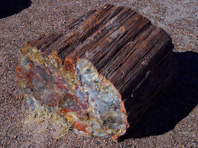


TRIP-READY SHORTLIST
Best-supported rockhounding sites in Oregon
This ranking favors current evidence, usable coordinates, navigation context and field readiness. It is not a popularity ranking and Conditional records still require verification.
Sharps Creek Recreation Site — Gold Panning
gold panning
Sixes River Campground — Gold Panning
gold panning
Cow Creek Back Country Byway / Island Creek Day Use Area — Gold Panning
gold panning
Quartzville Back Country Byway — Recreational Mining
gold panning / recreational mining
Agate Beach State Recreation Site / Newport
Bailey Beach / Gold Beach North Jetty — Agate & Quartz Hunting
Beverly Beach State Park — Agates, Petrified Wood & Loose Marine Fossils
Fogarty Creek State Recreation Area — Agate Hunting
Glass Buttes Obsidian Area
Hart Mountain National Antelope Refuge — Surface Rock Collection
OREGON MINERAL DISCOVERY
What can you find rockhounding in Oregon?
The atlas mixes visitor programs, stronger collecting leads, protected environments and geological research. Material record counts are not promises that collecting is allowed. Verify the exact location and manager before taking anything.
Identify Oregon rocks, minerals and fossils →
LAND, CLAIMS & PERMISSION
Who controls the land matters more than the mineral pin
The state map’s land-status and claim layers are planning aids. Exact ownership, claims, protected-resource rules and current manager guidance still control field use.
BLM sunstone area
Verify current BLM public boundaries and private mining claims before collecting.
Ocean shore
Only specified personal-use loose stones may be removable under current beach and park rules; protected areas differ.
Hart Mountain Refuge
Check current Fish and Wildlife Service surface-collection quantity and no-digging/tool limits.
Claims and protected lands
BLM/USFS mapping is not proof of open mineral rights; wilderness, parks and active claims can bar collection.
Travel hazards
Fire closures, desert heat, deep snow and rough roads change practical access.
WHEN TO GO
Oregon rockhounding seasonal planner
Stormy coast season
Strong surf can expose agates but water and storm hazards rise.
Spring desert window
Cooler weather helps eastern Oregon; mud and snow may block roads.
High-country summer
Road access improves while heat, fire restrictions and crowds increase.
Autumn field window
Cooler weather helps desert visits before winter road closures.
OREGON FIELD KIT
A practical field kit for Oregon
Match equipment to the site and collecting method rather than carrying heavy tools by default.
Identification kit
Hand lens, magnet, notebook, scale, specimen bags and labels help preserve context and reduce guesswork.
River / gravel kit
Use sturdy footwear, gloves and eye protection. Check water level, access and disturbance rules before entering a stream or shoreline.
Geode / hard-rock kit
Eye protection and small hand tools are more useful than heavy equipment. Never enter mine workings or unstable cuts.
Fossil kit
Camera, scale, notebook and protective wrapping allow documentation without assuming removal is legal.
Panning kit
A basic pan, classifier and vial are enough for many recreational contexts; powered equipment can trigger different rules.
Navigation & safety
Carry offline mapping, water, weather layers and an emergency plan appropriate to remoteness and season.
COMMUNITY FIELD INTELLIGENCE
Recent Oregon field reports
Approved visitor reports add current observations without automatically changing a location’s legal or access status.
Open any location guide and use Share Your Story & Photos. Reports remain pending until admin approval.
EXPLORE OREGON LOCALLY
Rockhounding near Oregon cities
Move from statewide discovery into nearby field regions and then into individual location guides. City pages rank nearby records by evidence status and distance instead of treating every geological occurrence as an open collecting site.
Oregon rockhounding regions and local areas
Regional pages group related geology and field opportunities without turning every mineral occurrence into a separate destination page.
Oregon location directory preview
Start with the current inventory, then open the complete searchable directory for all 256 records.
Sixes River Campground — Gold Panning
gold panning · Curry
Tseriadun State Recreation Site
· Curry
Cow Creek Back Country Byway / Island Creek Day Use Area — Gold Panning
gold panning · Douglas
Glass Buttes Obsidian Area
· Lake
Sharps Creek Recreation Site — Gold Panning
gold panning · Lane
Quartzville Back Country Byway — Recreational Mining
gold panning / recreational mining · Linn
Succor Creek State Natural Area
· Malheur
Oceanside Beach State Recreation Site
· Tillamook
Little Baby Prospect
Copper, Lead, Zinc, Vanadium
Oregon rockhounding: the map’s Ready status is not a statewide permit
Oregon’s map currently classifies 23 records as Ready. Those entries include beaches, public sunstone collecting, designated recreation sites and gold-panning locations, each with different rules. Ready is a starting point for checking evidence, not permission to collect any material anywhere at those coordinates. Review the manager, claim boundaries, tide and seasonal access for each destination.
Oregon Sunstone Public Collection Area
BLM’s Sunstone Public Collection Area lies in remote Rabbit Basin. The public collecting boundary is marked by posts, but private mining claims occur around and within the broader area. Collecting on a private claim without permission is prohibited. No fee is charged for hobby sunstone collection inside eligible public areas, but material cannot be taken for commercial trade under the public-area rules. Bring extra water, suitable tires, fuel and a reliable route plan; never invent a sunstone specimen coordinate from a road waypoint.
Glass Buttes obsidian and coast agates
Glass Buttes is known for volcanic glass with razor-sharp conchoidal fractures. Check exact BLM parcel restrictions and avoid archaeological obsidian artifacts, mining claims and private land. Coastal destinations such as Agate Beach and Whiskey Run require an ocean-shore access check: do not remove stones from sensitive cliffs, riprap, cultural sites or restricted areas. Watch high surf and sneaker waves.
Gold-panning sites and state recreation areas
Quartzville, Sharps Creek and Sixes River represent different management contexts. Hand panning, streambed excavation and motorized equipment are not interchangeable; water-quality rules, mineral claims and designated mineral withdrawals may apply.
Specimen guide: learn to distinguish natural sunstone feldspar, obsidian, agate, jasper and thundereggs in the Oregon identification guide before classifying a find.