CALIFORNIA INTERACTIVE FIELD MAP
Inspect places, geology, access evidence and nearby context
The map keeps collecting leads, protected places and research occurrences visually distinct.
Where are California geode and jasper collecting areas?
Wiley Well and Chambless are documented BLM-associated collecting areas, while the detailed guides linked here cover conditional gold-panning leads at Dave Moore, Greenwood Creek and Briceburg. Before collecting, verify the exact public parcel, active mining claims, protected resources and local restrictions.
Official source: BLM California collecting rules. Confirm the exact authority and current restrictions before collecting.
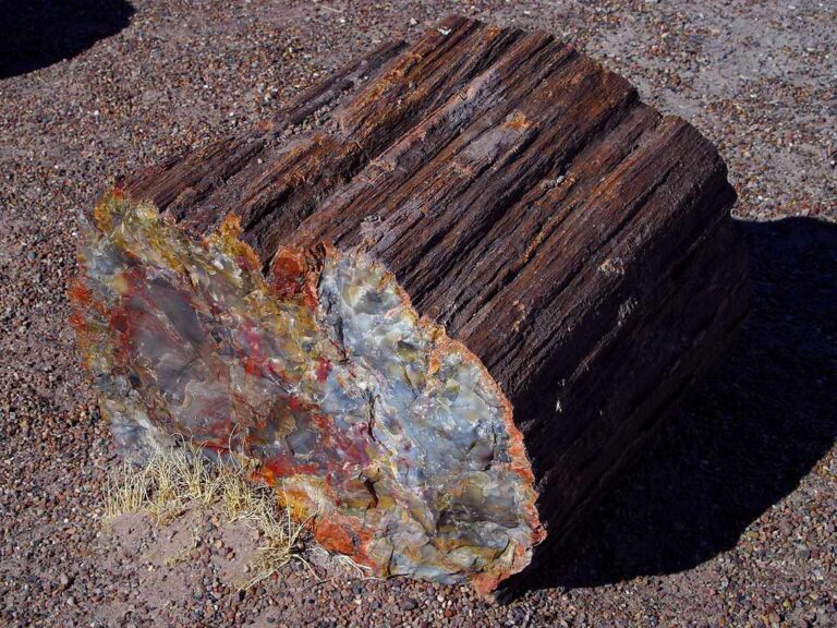
Rock and mineral reference images for California
These are real reference photographs from the site media library, not photographs of the exact mapped sites. Always confirm mineral identity and collection permissions separately.

EXPLORE CALIFORNIA LOCALLY
Rockhounding near California cities
Move from statewide discovery into nearby field regions and then into individual location guides. City pages rank nearby records by evidence status and distance instead of treating every geological occurrence as an open collecting site.
California rockhounding regions and local areas
Regional pages group related geology and field opportunities without turning every mineral occurrence into a separate destination page.
California location directory preview
Start with the current inventory, then open the complete searchable directory for all 256 records.
Indian Creek Campground — Rock Collecting Access
General rock collecting · Alpine
Dave Moore Nature Area — Gold Panning
Gold · El Dorado
Greenwood Creek River Access — Gold Panning
Gold · El Dorado
Cronan Ranch Trailhead — South Fork Access
Access only · El Dorado
Magnolia Ranch Trailhead — South Fork Access
Access only · El Dorado
Old Flume Trail Trailhead — South Fork Access
Access only · El Dorado
Briceburg Put-in — Gold Panning Access
Gold · Mariposa
Cable Rock Day Use Site — Gold Panning
Gold · Mariposa
McCabe Flat Campground — Gold Panning
Gold · Mariposa
Railroad Flat Campground — Gold Panning
Gold · Mariposa
Willow Placer Campground — Gold Panning
Gold · Mariposa
Euchre Bar Trailhead — North Fork American River Access
Access only · Placer
Stevens Trail Trailhead — North Fork Access
Access only · Placer
Coon Hollow Campground access
Access only · Riverside
Wiley's Well Campground access
Access only · Riverside
Union Flat Campground — North Yuba Recreational Mining Access
Access to gold-panning zone · Sierra
Curly Jack Campground — Klamath River Access
Access only · Siskiyou
Steiner Flat Primitive Campground — Gold Panning
Gold · Trinity
Chambless Rock Collecting Area
hematite, magnetite, epidote, limestone, marble, garnet and common fossils · San Bernardino
Wiley Well District Geode Beds
geodes, rocks, minerals and common fossils · Riverside
Savahia Peak Rock Collecting Area
chalcedony · San Bernardino
Flattop Mountain Rock Collecting Area
jasper · San Bernardino
Alhambra Mine
Gold, Silver, Copper, Lead, Zinc, Tungsten, Molybdenum
Lost Cabin
Gold, Silver, Copper, Lead
TRIP-READY SHORTLIST
Best-supported rockhounding sites in California
This ranking favors current evidence, usable coordinates, navigation context and field readiness. It is not a popularity ranking and Conditional records still require verification.
Chambless Rock Collecting Area
hematite, magnetite, epidote, limestone, marble, garnet and common fossils
Flattop Mountain Rock Collecting Area
jasper
Savahia Peak Rock Collecting Area
chalcedony
Wiley Well District Geode Beds
geodes, rocks, minerals and common fossils
Briceburg Put-in — Gold Panning Access
Gold
Cable Rock Day Use Site — Gold Panning
Gold
Dave Moore Nature Area — Gold Panning
Gold
Greenwood Creek River Access — Gold Panning
Gold
McCabe Flat Campground — Gold Panning
Gold
Railroad Flat Campground — Gold Panning
Gold
CALIFORNIA MATERIAL DISCOVERY
What can you find rockhounding in California?
Counts come from the live state inventory. They describe records mentioning a material, not guaranteed legal collecting sites.
Mining Districts
256 recordsCompare the strongest current examples, then open the individual guide for access and evidence status.
Gold & Placer
247 recordsCompare the strongest current examples, then open the individual guide for access and evidence status.
Fossils
5 recordsCompare the strongest current examples, then open the individual guide for access and evidence status.
Quartz & Crystals
4 recordsCompare the strongest current examples, then open the individual guide for access and evidence status.
Agate & Chalcedony
1 recordsCompare the strongest current examples, then open the individual guide for access and evidence status.
Jasper
1 recordsCompare the strongest current examples, then open the individual guide for access and evidence status.
Jade & Serpentine
0 recordsCompare the strongest current examples, then open the individual guide for access and evidence status.
No strong examples are currently surfaced for this material.
Volcanic Rocks
0 recordsCompare the strongest current examples, then open the individual guide for access and evidence status.
No strong examples are currently surfaced for this material.
LAND, CLAIMS & PERMISSION
Who controls the land matters more than the mineral pin
The state map’s land-status and claim layers are planning aids. Exact ownership, claims, protected-resource rules and current manager guidance still control field use.
Public land is not blanket permission
BLM and Forest Service parcels can contain withdrawals, claims, wilderness, cultural resources and local restrictions. Verify the exact unit before collecting.
Gold-country claims
Historic placer and lode districts can still contain active mineral rights. A river-access point does not cancel claim status.
State parks and protected units
Many beaches, parks, preserves and scientific localities are viewing or research contexts rather than collecting sites.
Private and managed access
Campgrounds, commercial operations and private roads have operator-specific rules, fees and hours.
River conditions
High water, fire closures, washed roads and seasonal restrictions can change practical access even where collecting is otherwise lawful.
WHEN TO GO
California rockhounding seasonal planner
Low-elevation and desert window
Desert fieldwork is often more practical while Sierra routes can remain snow-limited.
Spring transition
Foothill access improves, but snowmelt and high river flows can affect panning corridors.
High-country access and fire season
Mountain roads are more accessible while heat, wildfire closures and smoke become major constraints.
Cooler field window
Lower temperatures help desert and foothill work while early snow may close higher elevations.
CALIFORNIA FIELD KIT
A practical field kit for California
Match equipment to the site and collecting method rather than carrying heavy tools by default.
Identification kit
Hand lens, magnet, notebook, scale, specimen bags and labels help preserve context and reduce guesswork.
River / gravel kit
Use sturdy footwear, gloves and eye protection. Check water level, access and disturbance rules before entering a stream or shoreline.
Geode / hard-rock kit
Eye protection and small hand tools are more useful than heavy equipment. Never enter mine workings or unstable cuts.
Fossil kit
Camera, scale, notebook and protective wrapping allow documentation without assuming removal is legal.
Panning kit
A basic pan, classifier and vial are enough for many recreational contexts; powered equipment can trigger different rules.
Navigation & safety
Carry offline mapping, water, weather layers and an emergency plan appropriate to remoteness and season.
COMMUNITY FIELD INTELLIGENCE
Recent California field reports
Approved visitor reports add current observations without automatically changing a location’s legal or access status.
Open any location guide and use Share Your Story & Photos. Reports remain pending until admin approval.