MISSISSIPPI INTERACTIVE FIELD MAP
Inspect places, geology, access evidence and nearby context
The map keeps collecting leads, protected places and research occurrences visually distinct.
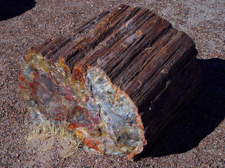
Rock and mineral reference images for Mississippi
These are real reference photographs from the site media library, not photographs of the exact mapped sites. Always confirm mineral identity and collection permissions separately.


TRIP-READY SHORTLIST
Best-supported rockhounding sites in Mississippi
This ranking favors current evidence, usable coordinates, navigation context and field readiness. It is not a popularity ranking and Conditional records still require verification.
Jellystone Park Pelahatchie — Managed Gem Mining
operator-provided gem-mining material; take-home treasures
LeFleur’s Mining Company Gem Sluice — Mississippi Museum of Natural Science
purchased gem pay dirt and fossil bags; take-home gems and fossils
Mississippi Petrified Forest — Managed Gem Mining Flume
operator-provided mine muck containing gems/minerals for flume washing; take-home finds
Mississippi Gravel Agate/Petrified-Wood Hunting — Rights-Gated Context
agate, carnelian, jasper, chalcedony, petrified wood and chert gravel
Mississippi Stream-Gravel Fossil Hunting — Rights-Gated Context
common chert invertebrate fossils from reworked gravels
National Forests in Mississippi — Casual Rock/Mineral Collecting
small amounts of common rocks/minerals for personal noncommercial use where allowed
National Forests in Mississippi — Recreational Mineral Prospecting/Panning Context
hand panning or low-disturbance mineral prospecting where mineral status and local rules allow
MISSISSIPPI MINERAL DISCOVERY
What can you find rockhounding in Mississippi?
The atlas mixes visitor programs, stronger collecting leads, protected environments and geological research. Material record counts are not promises that collecting is allowed. Verify the exact location and manager before taking anything.
Identify Mississippi rocks, minerals and fossils →
Petrified Wood & Silicified Logs
89 recordsMississippi's petrified wood interests relate to buried ancient forests and reworked sediments. State and private ownership govern removal.
Mississippi Agate & Chalcedony
2 recordsRounded silica pieces can appear in river gravels; identification needs hardness and fracture, not only color.
Marine Fossils & Eocene Shell Beds
104 recordsCoastal Plain marine formations contain important fossil research; roadcuts and private exposures require special care.
Chert, Flint & River Gravel
109 recordsMississippi river-system deposits contain durable transported chert and silica. Archaeological artifacts are not rockhounding specimens.
Catahoula Formation Silica/Opal Research
1 recordsHistoric opal/silica notes are research-only until verified geology, exact property boundaries and owner permission are established.
Ironstone, Limonite & Concretions
98 recordsIron oxides can stain rocks and fossils; yellow or red color alone is insufficient identification.
Quartz, Jasper & Creek Pebbles
4 recordsTransported silica materials may occur across river terraces; exact collecting authority is parcel-specific.
Cretaceous Chalk & Black Belt Fossils
1 recordsThe Black Belt and related formations preserve major paleontological context; protected scientific sites are viewing/research only.
LAND, CLAIMS & PERMISSION
Who controls the land matters more than the mineral pin
The state map’s land-status and claim layers are planning aids. Exact ownership, claims, protected-resource rules and current manager guidance still control field use.
Private riverbanks and gravel pits
Mississippi stream and pit geology does not create public collection rights. Check owner and exact location.
Petrified wood sites
A fossil wood occurrence is not an authorization to remove wood or excavate on private or public land.
Archaeological artifacts
Do not collect cultural objects or disturb protected mounds and archaeological sites.
Protected coastal units
National Seashore and other protected Gulf Coast units regulate or prohibit removing natural materials.
Roadcut and mine safety
Avoid roadside stops without safe legal access, and never enter unstable pits or mine excavations.
WHEN TO GO
Mississippi rockhounding seasonal planner
Coolest field season
Lower vegetation improves geology observation; river flooding can still interrupt.
Spring survey window
Mild conditions, heavy rains and high creeks require location-specific planning.
Hot/humid season
Heat, insects, thunderstorms and flash floods are major constraints.
Autumn research window
More comfortable temperatures but tropical storms and flooded lowlands can still occur.
MISSISSIPPI FIELD KIT
A practical field kit for Mississippi
Match equipment to the site and collecting method rather than carrying heavy tools by default.
Identification kit
Hand lens, magnet, notebook, scale, specimen bags and labels help preserve context and reduce guesswork.
River / gravel kit
Use sturdy footwear, gloves and eye protection. Check water level, access and disturbance rules before entering a stream or shoreline.
Geode / hard-rock kit
Eye protection and small hand tools are more useful than heavy equipment. Never enter mine workings or unstable cuts.
Fossil kit
Camera, scale, notebook and protective wrapping allow documentation without assuming removal is legal.
Panning kit
A basic pan, classifier and vial are enough for many recreational contexts; powered equipment can trigger different rules.
Navigation & safety
Carry offline mapping, water, weather layers and an emergency plan appropriate to remoteness and season.
COMMUNITY FIELD INTELLIGENCE
Recent Mississippi field reports
Approved visitor reports add current observations without automatically changing a location’s legal or access status.
Open any location guide and use Share Your Story & Photos. Reports remain pending until admin approval.
EXPLORE MISSISSIPPI LOCALLY
Rockhounding near Mississippi cities
Move from statewide discovery into nearby field regions and then into individual location guides. City pages rank nearby records by evidence status and distance instead of treating every geological occurrence as an open collecting site.
Mississippi rockhounding regions and local areas
Regional pages group related geology and field opportunities without turning every mineral occurrence into a separate destination page.
Mississippi location directory preview
Start with the current inventory, then open the complete searchable directory for all 368 records.
Adams County Geology and Rock/Fossil Research
surface geology, chert gravels, fossils, petrified wood, industrial minerals and historic mining/resource context · Adams
Alcorn County Geology and Rock/Fossil Research
surface geology, chert gravels, fossils, petrified wood, industrial minerals and historic mining/resource context · Alcorn
Amite County Geology and Rock/Fossil Research
surface geology, chert gravels, fossils, petrified wood, industrial minerals and historic mining/resource context · Amite
Attala County Geology and Rock/Fossil Research
surface geology, chert gravels, fossils, petrified wood, industrial minerals and historic mining/resource context · Attala
Benton County Geology and Rock/Fossil Research
surface geology, chert gravels, fossils, petrified wood, industrial minerals and historic mining/resource context · Benton
Bolivar County Geology and Rock/Fossil Research
surface geology, chert gravels, fossils, petrified wood, industrial minerals and historic mining/resource context · Bolivar
Calhoun County Geology and Rock/Fossil Research
surface geology, chert gravels, fossils, petrified wood, industrial minerals and historic mining/resource context · Calhoun
Carroll County Geology and Rock/Fossil Research
surface geology, chert gravels, fossils, petrified wood, industrial minerals and historic mining/resource context · Carroll
Mississippi Lignite & Fossil-Wood Research
lignite, carbonized wood and silicification processes · Central / northern Coastal Plain
Mississippi Eocene Marine Fossil Research
Eocene marine vertebrate/invertebrate fossil contexts · Central Mississippi
Chickasaw County Geology and Rock/Fossil Research
surface geology, chert gravels, fossils, petrified wood, industrial minerals and historic mining/resource context · Chickasaw
Choctaw County Geology and Rock/Fossil Research
surface geology, chert gravels, fossils, petrified wood, industrial minerals and historic mining/resource context · Choctaw
Claiborne County Geology and Rock/Fossil Research
surface geology, chert gravels, fossils, petrified wood, industrial minerals and historic mining/resource context · Claiborne
Mississippi Catahoula Formation Opal Research
rare opal occurrence and silicified sediment research · Claiborne / southwest Mississippi
Clarke County Geology and Rock/Fossil Research
surface geology, chert gravels, fossils, petrified wood, industrial minerals and historic mining/resource context · Clarke
Clay County Geology and Rock/Fossil Research
surface geology, chert gravels, fossils, petrified wood, industrial minerals and historic mining/resource context · Clay
Coahoma County Geology and Rock/Fossil Research
surface geology, chert gravels, fossils, petrified wood, industrial minerals and historic mining/resource context · Coahoma
Copiah County Geology and Rock/Fossil Research
surface geology, chert gravels, fossils, petrified wood, industrial minerals and historic mining/resource context · Copiah
Covington County Geology and Rock/Fossil Research
surface geology, chert gravels, fossils, petrified wood, industrial minerals and historic mining/resource context · Covington
DeSoto County Geology and Rock/Fossil Research
surface geology, chert gravels, fossils, petrified wood, industrial minerals and historic mining/resource context · DeSoto
Mississippi River Alluvium Research
river alluvium, gravel, sand and reworked fossils · Delta / western counties
National Forests in Mississippi — Recreational Mineral Prospecting/Panning Context
hand panning or low-disturbance mineral prospecting where mineral status and local rules allow · Eligible National Forest System parcels statewide
Forrest County Geology and Rock/Fossil Research
surface geology, chert gravels, fossils, petrified wood, industrial minerals and historic mining/resource context · Forrest
Franklin County Geology and Rock/Fossil Research
surface geology, chert gravels, fossils, petrified wood, industrial minerals and historic mining/resource context · Franklin