NORTH DAKOTA INTERACTIVE FIELD MAP
Inspect places, geology, access evidence and nearby context
The map keeps collecting leads, protected places and research occurrences visually distinct.
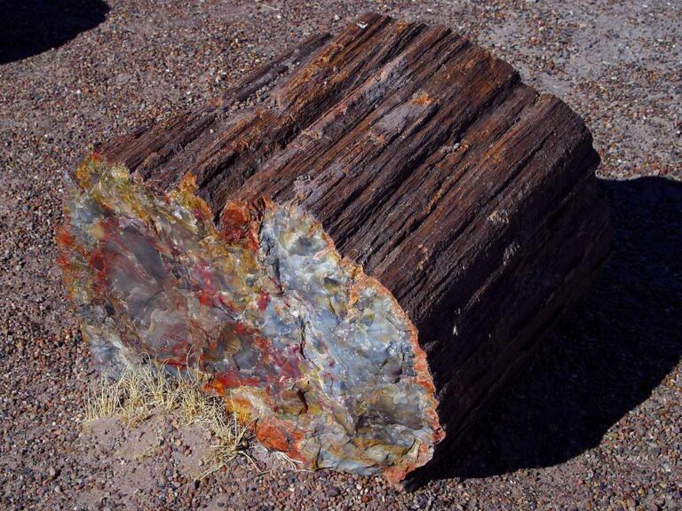
Rock and mineral reference images for North Dakota
These are real reference photographs from the site media library, not photographs of the exact mapped sites. Always confirm mineral identity and collection permissions separately.


TRIP-READY SHORTLIST
Best-supported rockhounding sites in North Dakota
This ranking favors current evidence, usable coordinates, navigation context and field readiness. It is not a popularity ranking and Conditional records still require verification.
BLM North Dakota Public Lands — Casual Rock / Mineral Collection Context
common rocks, mineral specimens, semiprecious material
BLM North Dakota Public Lands — Common Invertebrate / Plant Fossil & Petrified Wood Context
common invertebrate fossils, plant fossils and petrified wood
Dakota Prairie Grasslands — Rock / Mineral / Fossil Context
common rocks, minerals, petrified wood and fossil context
NDGS Public Fossil Digs — Next Published Season / Registration Gate
scientifically collected fossils under NDGS supervision
North Dakota Private Quarry / Gravel Pit / Landowner Field Trips
agates, jasper, quartz, calcite, petrified wood and gravel-source material
NORTH DAKOTA MINERAL DISCOVERY
What can you find rockhounding in North Dakota?
The atlas mixes visitor programs, stronger collecting leads, protected environments and geological research. Material record counts are not promises that collecting is allowed. Verify the exact location and manager before taking anything.
Identify North Dakota rocks, minerals and fossils →
Petrified Wood & Fossil Wood
12 recordsSilicified wood occurs in regional sedimentary deposits. Teredo-bored petrified wood is North Dakota’s state fossil, and many localities have protected-resource restrictions.
Agate, Chalcedony & Jasper
10 recordsGlacial gravels and western badlands sediments provide silica material context; distinguish bands and hardness from colorful concretion coatings.
Badlands Vertebrate & Marine Fossils
96 recordsBadlands fossil strata have immense scientific value. Collection of vertebrate fossils on federal and protected lands is generally restricted and may require permits.
Quartz & Glacial Cobbles
80 recordsIce-transported pebbles can originate far from the immediate bedrock, so a river cobble cannot by itself establish a local mineral deposit.
Ironstone & Concretions
2 recordsSedimentary concretion textures can resemble fossils or ore, especially in weathered Badlands beds.
Lignite, Coal & Sedimentary Beds
4 recordsFort Union Group sediments include lignite and fossil-bearing units; industrial and protected contexts require care.
Calcite, Gypsum & Carbonates
1 recordsSoft carbonate or evaporite minerals in layered sedimentary rocks should be distinguished using cleavage and hardness.
Little Missouri & Red River Gravel
80 recordsRiver gravels can contain agate, chert and quartz; access and sediment disturbance depend on exact bank ownership and current rules.
LAND, CLAIMS & PERMISSION
Who controls the land matters more than the mineral pin
The state map’s land-status and claim layers are planning aids. Exact ownership, claims, protected-resource rules and current manager guidance still control field use.
National parks
Theodore Roosevelt National Park protects fossils, rocks and natural features; do not remove material without explicit legal authorization.
Fossil type matters
Federal laws distinguish common invertebrate/plant fossils from vertebrate fossils; federal permits and land-unit rules may apply.
State and local public land
Park and state-land rules vary; a public parcel is not automatically open for specimen removal.
Private ranches and mines
Many western fossil localities cross private land or leases; obtain permission and respect mineral/resource rights.
River gravel
Riverside access and collection require exact ownership and current water or disturbance restrictions.
WHEN TO GO
North Dakota rockhounding seasonal planner
Severe winter conditions
Snow, wind and freezing temperatures limit Badlands and river travel.
Spring access recovery
Mud, flash flooding and closed roads may persist while valleys begin opening.
Badlands field window
Heat, lightning and rapid thunderstorms can make exposed slopes hazardous.
Cool-weather research
More comfortable terrain access until snow and freezing weather return.
NORTH DAKOTA FIELD KIT
A practical field kit for North Dakota
Match equipment to the site and collecting method rather than carrying heavy tools by default.
Identification kit
Hand lens, magnet, notebook, scale, specimen bags and labels help preserve context and reduce guesswork.
River / gravel kit
Use sturdy footwear, gloves and eye protection. Check water level, access and disturbance rules before entering a stream or shoreline.
Geode / hard-rock kit
Eye protection and small hand tools are more useful than heavy equipment. Never enter mine workings or unstable cuts.
Fossil kit
Camera, scale, notebook and protective wrapping allow documentation without assuming removal is legal.
Panning kit
A basic pan, classifier and vial are enough for many recreational contexts; powered equipment can trigger different rules.
Navigation & safety
Carry offline mapping, water, weather layers and an emergency plan appropriate to remoteness and season.
COMMUNITY FIELD INTELLIGENCE
Recent North Dakota field reports
Approved visitor reports add current observations without automatically changing a location’s legal or access status.
Open any location guide and use Share Your Story & Photos. Reports remain pending until admin approval.
EXPLORE NORTH DAKOTA LOCALLY
Rockhounding near North Dakota cities
Move from statewide discovery into nearby field regions and then into individual location guides. City pages rank nearby records by evidence status and distance instead of treating every geological occurrence as an open collecting site.
North Dakota rockhounding regions and local areas
Regional pages group related geology and field opportunities without turning every mineral occurrence into a separate destination page.
North Dakota location directory preview
Start with the current inventory, then open the complete searchable directory for all 344 records.
Adams County — Rock, Mineral & Fossil Research Matrix
county-scale bedrock, surficial, mineral-resource and fossil geology · Adams
Barnes County — Rock, Mineral & Fossil Research Matrix
county-scale bedrock, surficial, mineral-resource and fossil geology · Barnes
Sheyenne River Gravel & Glacial Deposit Research
glacial cobbles, quartzite, agate and sedimentary material · Barnes / Ransom / Richland / Cass / Griggs / Eddy
Benson County — Rock, Mineral & Fossil Research Matrix
county-scale bedrock, surficial, mineral-resource and fossil geology · Benson
Billings County — Rock, Mineral & Fossil Research Matrix
county-scale bedrock, surficial, mineral-resource and fossil geology · Billings
Medora / Sentinel Butte Formation Research
petrified wood, plant fossils, mollusks and Paleocene geology · Billings
Theodore Roosevelt NPS Resource Firewall
rocks, fossils and petrified wood · Billings / McKenzie
Theodore Roosevelt National Park — Rocks / Fossils / Petrified Wood Protected
rocks, fossils, petrified wood and badlands geology · Billings / McKenzie
Little Missouri River Agate / Jasper / Petrified Wood Research
agate, jasper, chalcedony and petrified wood · Billings / McKenzie / Dunn / Slope / Golden Valley
Western North Dakota Clinker / Scoria Research
clinker, baked shale, lignite and badlands erosional geology · Billings / McKenzie / Dunn / Stark / Slope / Golden Valley
Bottineau County — Rock, Mineral & Fossil Research Matrix
county-scale bedrock, surficial, mineral-resource and fossil geology · Bottineau
Souris / Mouse River Gravel Research
glacial gravel, quartz, agate and mixed erratics · Bottineau / McHenry / Ward / Renville
Turtle Mountains Glacial Geology Research
glacial till, erratics, gravel and upland geology · Bottineau / Rolette
Bowman County — Rock, Mineral & Fossil Research Matrix
county-scale bedrock, surficial, mineral-resource and fossil geology · Bowman
Western North Dakota Uranium / Volcanic Ash Research
uranium-bearing lignite context, volcanic ash and associated minerals · Bowman / Slope / Billings
Burke County — Rock, Mineral & Fossil Research Matrix
county-scale bedrock, surficial, mineral-resource and fossil geology · Burke
Burleigh County — Rock, Mineral & Fossil Research Matrix
county-scale bedrock, surficial, mineral-resource and fossil geology · Burleigh
Bismarck / Mandan Hell Creek Fossil Research
Hell Creek dinosaur and associated vertebrate fossil context · Burleigh / Morton
Cass County — Rock, Mineral & Fossil Research Matrix
county-scale bedrock, surficial, mineral-resource and fossil geology · Cass
Cavalier County — Rock, Mineral & Fossil Research Matrix
county-scale bedrock, surficial, mineral-resource and fossil geology · Cavalier
Pembina Gorge Pierre Shale Fossil Research
marine reptile, mollusk and Pierre Shale fossil context · Cavalier / Pembina
Dickey County — Rock, Mineral & Fossil Research Matrix
county-scale bedrock, surficial, mineral-resource and fossil geology · Dickey
Divide County — Rock, Mineral & Fossil Research Matrix
county-scale bedrock, surficial, mineral-resource and fossil geology · Divide
Dunn County — Rock, Mineral & Fossil Research Matrix
county-scale bedrock, surficial, mineral-resource and fossil geology · Dunn