OKLAHOMA INTERACTIVE FIELD MAP
Inspect places, geology, access evidence and nearby context
The map keeps collecting leads, protected places and research occurrences visually distinct.
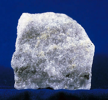
Rock and mineral reference images for Oklahoma
These are real reference photographs from the site media library, not photographs of the exact mapped sites. Always confirm mineral identity and collection permissions separately.



TRIP-READY SHORTLIST
Best-supported rockhounding sites in Oklahoma
This ranking favors current evidence, usable coordinates, navigation context and field readiness. It is not a popularity ranking and Conditional records still require verification.
Salt Plains National Wildlife Refuge — Selenite Crystal Digging Area
hourglass selenite crystals (gypsum)
Ouachita National Forest — Oklahoma Rockhounding Permit Context
quartz, novaculite, sandstone and other common rock/mineral occurrences
OKLAHOMA MINERAL DISCOVERY
What can you find rockhounding in Oklahoma?
The atlas mixes visitor programs, stronger collecting leads, protected environments and geological research. Material record counts are not promises that collecting is allowed. Verify the exact location and manager before taking anything.
Identify Oklahoma rocks, minerals and fossils →
LAND, CLAIMS & PERMISSION
Who controls the land matters more than the mineral pin
The state map’s land-status and claim layers are planning aids. Exact ownership, claims, protected-resource rules and current manager guidance still control field use.
Great Salt Plains refuge
Only the designated seasonal digging area allows the specified crystal activity; check closure dates and method limits.
Ouachita forest
Confirm current permit rules and an Oklahoma-side authorized location.
Wildlife refuges and parks
Wichita Mountains and many state/federal units are viewing rather than rock-removal locations.
Rose rocks
Secure landowner permission on Garber Sandstone exposures.
Mining contamination
Avoid Picher–Tar Creek mine tailings, unstable workings and contaminated sites.
WHEN TO GO
Oklahoma rockhounding seasonal planner
Winter planning
Flooded flats and closure schedules limit crystal digging.
Spring mineral season
Confirm refuge dig dates; severe storms and flash floods matter.
Hot weather
Exposed salt flats and western hills have severe heat hazards.
Cooler autumn
Check scheduled refuge closure and safe road conditions.
OKLAHOMA FIELD KIT
A practical field kit for Oklahoma
Match equipment to the site and collecting method rather than carrying heavy tools by default.
Identification kit
Hand lens, magnet, notebook, scale, specimen bags and labels help preserve context and reduce guesswork.
River / gravel kit
Use sturdy footwear, gloves and eye protection. Check water level, access and disturbance rules before entering a stream or shoreline.
Geode / hard-rock kit
Eye protection and small hand tools are more useful than heavy equipment. Never enter mine workings or unstable cuts.
Fossil kit
Camera, scale, notebook and protective wrapping allow documentation without assuming removal is legal.
Panning kit
A basic pan, classifier and vial are enough for many recreational contexts; powered equipment can trigger different rules.
Navigation & safety
Carry offline mapping, water, weather layers and an emergency plan appropriate to remoteness and season.
COMMUNITY FIELD INTELLIGENCE
Recent Oklahoma field reports
Approved visitor reports add current observations without automatically changing a location’s legal or access status.
Open any location guide and use Share Your Story & Photos. Reports remain pending until admin approval.
EXPLORE OKLAHOMA LOCALLY
Rockhounding near Oklahoma cities
Move from statewide discovery into nearby field regions and then into individual location guides. City pages rank nearby records by evidence status and distance instead of treating every geological occurrence as an open collecting site.
Oklahoma rockhounding regions and local areas
Regional pages group related geology and field opportunities without turning every mineral occurrence into a separate destination page.
Oklahoma location directory preview
Start with the current inventory, then open the complete searchable directory for all 377 records.
Adair County Rockhounding & Geology Research Index
county geology, stratigraphy, fossils and mineral occurrence research · Adair
Salt Plains Crystal Retention Contract
10 lb plus one large cluster per person/day · Alfalfa
Salt Plains Crystal Season Gate
April 1–October 15 crystal season · Alfalfa
Salt Plains Dig Method Contract
two-foot maximum hole depth · Alfalfa
Salt Plains Named Exception Non-Bleed
refuge geofence · Alfalfa
Great Salt Plains Lake — USACE Project Lands
natural formations, minerals and paleontological resources · Alfalfa
Salt Plains NWR — Outside Designated Crystal Dig Area
selenite/salt-flat natural resources · Alfalfa
Salt Plains National Wildlife Refuge — Selenite Crystal Digging Area
hourglass selenite crystals (gypsum) · Alfalfa
Alfalfa County Rockhounding & Geology Research Index
Permian red beds, gypsum/salt and sedimentary mineral occurrence research · Alfalfa
Atoka County Rockhounding & Geology Research Index
Ouachita sandstone/shale/novaculite/quartz geology and mineral occurrence research · Atoka
Beaver County Rockhounding & Geology Research Index
High Plains sedimentary geology, petrified-wood/fossil and mineral occurrence research · Beaver
Beckham County Rockhounding & Geology Research Index
Permian red beds, gypsum/salt and sedimentary mineral occurrence research · Beckham
Blaine County Rockhounding & Geology Research Index
Permian red beds, gypsum/salt and sedimentary mineral occurrence research · Blaine
Western Oklahoma Gypsum Belt
gypsum, selenite and evaporite geology · Blaine / Major / Woods / Woodward / Harper
Bryan County Rockhounding & Geology Research Index
county geology, stratigraphy, fossils and mineral occurrence research · Bryan
Caddo County Rockhounding & Geology Research Index
county geology, stratigraphy, fossils and mineral occurrence research · Caddo
Canadian County Rockhounding & Geology Research Index
Garber Sandstone, barite-rose/iron-rich sandstone and fossil/mineral occurrence research · Canadian
Carter County Rockhounding & Geology Research Index
Arbuckle carbonate/structural geology, fossils, limestone and mineral occurrence research · Carter
Cherokee County Rockhounding & Geology Research Index
northeastern chert/limestone, lead-zinc/tripoli and fossil/mineral occurrence research · Cherokee
Choctaw County Rockhounding & Geology Research Index
county geology, stratigraphy, fossils and mineral occurrence research · Choctaw
Black Mesa State Park / Nature Preserve
basalt, mesa geology and protected natural resources · Cimarron
Black Mesa & Kenton Volcanic Geology
basaltic caprock and High Plains geology · Cimarron
Cimarron County Rockhounding & Geology Research Index
High Plains strata, basaltic caprock, fossils and regional mineral occurrences · Cimarron
Cleveland County Rockhounding & Geology Research Index
Garber Sandstone, barite-rose/iron-rich sandstone and fossil/mineral occurrence research · Cleveland