WYOMING INTERACTIVE FIELD MAP
Inspect places, geology, access evidence and nearby context
The map keeps collecting leads, protected places and research occurrences visually distinct.
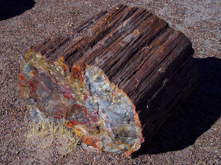
Rock and mineral reference images for Wyoming
These are real reference photographs from the site media library, not photographs of the exact mapped sites. Always confirm mineral identity and collection permissions separately.


TRIP-READY SHORTLIST
Best-supported rockhounding sites in Wyoming
This ranking favors current evidence, usable coordinates, navigation context and field readiness. It is not a popularity ranking and Conditional records still require verification.
American Fossil — Private Green River Formation Dig
Eocene fossil fish, plants and rare vertebrates
Fossil Lake Safari — Private Fossil Dig
Eocene fossil fish, plants and other Green River Formation fossils
In Stone Fossils — Private Fossil Dig
Green River Formation fossils
Nature’s Treasures — Fossil Fish Adventures
Green River Formation fossil fish
Tynsky’s Fossil Fish — Private Quarry Dig
Green River Formation fossil fish
Ulrich’s Fossil Gallery — Quarry Dig
Eocene fossil fish
Big Cedar Ridge Fossil Site — Common Fossil Collection Class Guide
Cretaceous plant fossils and paleoecology; common plant/invertebrate fossil class
Bighorn National Forest — Rockhounding Rule & Area Guide
Rocks and mineral specimens
Black Hills National Forest (Wyoming) — Rockhounding Rule Guide
Small surface rocks and minerals; prospecting context
Encampment River Canyon WSA — Named BLM Rockhounding
General rockhounding; exact material/rights/access confirmation required
WYOMING MINERAL DISCOVERY
What can you find rockhounding in Wyoming?
The atlas mixes visitor programs, stronger collecting leads, protected environments and geological research. Material record counts are not promises that collecting is allowed. Verify the exact location and manager before taking anything.
Identify Wyoming rocks, minerals and fossils →
Wyoming Jade & Nephrite
14 recordsFremont County and South Pass jade float occurrences require mineral rights and exact claim checks; a historic mine is not an open dig.
Blue Forest & Petrified Wood
5 recordsSilicified Eocene wood in the Green River Basin can be collected on eligible BLM lands subject to limits, but protected parcels and claims vary.
Green River Formation Fossils
19 recordsFossil fish quarries offer operator-managed experiences; federal vertebrate fossils require scientific permits and are not casual collectibles.
Agate, Chalcedony & Jasper
4 recordsRiver gravels, the Bighorn Basin and volcanic terrain contain silica specimens; the actual material mix and ownership vary.
South Pass Gold & Historic Placers
10 recordsPanning and mineral prospecting around South Pass depend on existing mining claims, private ground and land disturbance limits.
Quartz, Garnet & Pegmatite
1 recordsMountain metamorphic and igneous districts provide mineral identification and quarry research, often restricted.
Copper, Iron & Mining Districts
285 recordsOre-district context is useful for mineral identification; abandoned shafts and workings must never be entered.
Geodes & Concretions
0 recordsConcretionary sedimentary formations and silica cavities need careful identification; some visually similar objects are protected fossils.
No strong examples are currently surfaced for this material.
LAND, CLAIMS & PERMISSION
Who controls the land matters more than the mineral pin
The state map’s land-status and claim layers are planning aids. Exact ownership, claims, protected-resource rules and current manager guidance still control field use.
BLM noncommercial rockhounding
On eligible BLM Wyoming lands, reasonable personal-use collection of common rocks, mineral specimens and gems is generally allowed with hand tools and minimal disturbance. Check current parcel, claims and special closures.
Petrified wood quantities
BLM permits up to 25 pounds plus one piece per person per day, maximum 250 pounds yearly, where collection is otherwise allowed. Material cannot be sold or combined to move larger pieces.
Fossils and the Green River Formation
Common invertebrate/plant fossils may have limited casual collecting rules, but vertebrate fossils, uncommon paleontology, and fossil tracks require research permits on federal land. Managed private quarries have separate owner rules.
Parks, reservations and wilderness
Yellowstone, Grand Teton and Fossil Butte National Monument protect rocks and fossils. Tribal lands, wilderness restrictions and archaeological resources require special treatment.
Mines, remoteness and weather
Claimholder rights, private leases, abandoned mine dangers and snowbound/remote roads can make a famous occurrence unsuitable for field collection.
WHEN TO GO
Wyoming rockhounding seasonal planner
Severe mountain winter
Deep snow, black ice and short daylight curtail many routes and private quarry operations.
Spring reopening
Mud and thaw restrict desert tracks; confirm quarry access and road condition.
Main high-desert field season
Long days assist travel, but lightning and extreme exposure affect open basins.
Autumn rockhounding
Cooler basin conditions are favorable until early mountain snow arrives.
WYOMING FIELD KIT
A practical field kit for Wyoming
Match equipment to the site and collecting method rather than carrying heavy tools by default.
Identification kit
Hand lens, magnet, notebook, scale, specimen bags and labels help preserve context and reduce guesswork.
River / gravel kit
Use sturdy footwear, gloves and eye protection. Check water level, access and disturbance rules before entering a stream or shoreline.
Geode / hard-rock kit
Eye protection and small hand tools are more useful than heavy equipment. Never enter mine workings or unstable cuts.
Fossil kit
Camera, scale, notebook and protective wrapping allow documentation without assuming removal is legal.
Panning kit
A basic pan, classifier and vial are enough for many recreational contexts; powered equipment can trigger different rules.
Navigation & safety
Carry offline mapping, water, weather layers and an emergency plan appropriate to remoteness and season.
COMMUNITY FIELD INTELLIGENCE
Recent Wyoming field reports
Approved visitor reports add current observations without automatically changing a location’s legal or access status.
Open any location guide and use Share Your Story & Photos. Reports remain pending until admin approval.
EXPLORE WYOMING LOCALLY
Rockhounding near Wyoming cities
Move from statewide discovery into nearby field regions and then into individual location guides. City pages rank nearby records by evidence status and distance instead of treating every geological occurrence as an open collecting site.
Wyoming rockhounding regions and local areas
Regional pages group related geology and field opportunities without turning every mineral occurrence into a separate destination page.
Wyoming location directory preview
Start with the current inventory, then open the complete searchable directory for all 294 records.
Laramie Mountains — Jade Research Explainer
Nephrite jade · Albany/Converse
Red Gulch Dinosaur Tracksite — Vertebrate Track Viewing Control
Dinosaur tracks; common fossils in surrounding BLM context · Big Horn
Encampment River Canyon WSA — Named BLM Rockhounding
General rockhounding; exact material/rights/access confirmation required · Carbon
Prospect Mountain WSA — Named BLM Rockhounding
General rockhounding; exact material class and rights screen required · Carbon
Seminoe Mountains — Jade Research Explainer
Nephrite jade · Carbon
Black Hills National Forest (Wyoming) — Rockhounding Rule Guide
Small surface rocks and minerals; prospecting context · Crook / Weston
Atlantic City / Big Atlantic Gulch — 2026 Access & Prospecting Research
Historic gold district and prospecting context · Fremont
Green Mountain — Jade & Agate Research Explainer
Jade and agate · Fremont
South Pass Historic Mining Area — Gold Research Explainer
Gold and historic mining geology · Fremont
Wiggins Fork Agate — Research Explainer
Agate · Fremont
Granite Mountains — Wyoming Jade Research Explainer
Nephrite jade · Fremont/Natrona
Rattlesnake Hills — Gem & Mineral Research Explainer
Jade-related geology and gemstone exploration context · Fremont/Natrona
Dry Creek Petrified Tree Environmental Education Area
In-place petrified tree remnants · Johnson
American Fossil — Private Green River Formation Dig
Eocene fossil fish, plants and rare vertebrates · Lincoln
Fossil Lake Safari — Private Fossil Dig
Eocene fossil fish, plants and other Green River Formation fossils · Lincoln
In Stone Fossils — Private Fossil Dig
Green River Formation fossils · Lincoln
Nature’s Treasures — Fossil Fish Adventures
Green River Formation fossil fish · Lincoln
Tynsky’s Fossil Fish — Private Quarry Dig
Green River Formation fossil fish · Lincoln
Ulrich’s Fossil Gallery — Quarry Dig
Eocene fossil fish · Lincoln
Blue Moon Quarry — Private Fossil Dig
Green River Formation fossil fish and associated fossils · Lincoln
Fossil Butte 2026 Research Quarry Program — Participate, No Keep
Eocene fossils · Lincoln
Fossil Butte National Monument — No-Keep Protected Fossils
Eocene fossils and geologic resources · Lincoln
Bighorn National Forest — Rockhounding Rule & Area Guide
Rocks and mineral specimens · Multiple
Bridger-Teton National Forest — Mineral Entry & Rockhounding Research Guide
Rocks, minerals and prospecting context · Multiple