WASHINGTON INTERACTIVE FIELD MAP
Inspect places, geology, access evidence and nearby context
The map keeps collecting leads, protected places and research occurrences visually distinct.
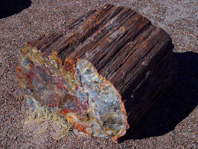
Rock and mineral reference images for Washington
These are real reference photographs from the site media library, not photographs of the exact mapped sites. Always confirm mineral identity and collection permissions separately.


TRIP-READY SHORTLIST
Best-supported rockhounding sites in Washington
This ranking favors current evidence, usable coordinates, navigation context and field readiness. It is not a popularity ranking and Conditional records still require verification.
Saddle Mountains — Petrified Wood
Petrified wood
Stonerose / Boot Hill Fossil Site
Eocene plant/invertebrate fossils under managed program
Red Top Trail — Agate Beds
Agate beds / chalcedony-lapidary material
WASHINGTON MINERAL DISCOVERY
What can you find rockhounding in Washington?
The atlas mixes visitor programs, stronger collecting leads, protected environments and geological research. Material record counts are not promises that collecting is allowed. Verify the exact location and manager before taking anything.
Identify Washington rocks, minerals and fossils →
Agates, Jasper & Ellensburg Blue
7 recordsAgates range from Teanaway/Ellensburg blue to Columbia Plateau gravels, with some sources on private or managed parcels.
Petrified Wood
5 recordsThe Saddle Mountains and Columbia Basin are known for silicified wood; Ginkgo Petrified Forest State Park resources are protected.
Quartz Crystals & Geodes
4 recordsCascade and Teanaway hard-rock districts contain quartz and geode research, requiring current forest and claim review.
Eocene Leaf & Invertebrate Fossils
12 recordsStonerose Interpretive Center manages a fossil dig program with specific admission and retention terms; other fossil sites are protected.
Gold & Historic Placer
156 recordsWashington DNR distinguishes state aquatic authorizations from State Trust land, where recreational panning is not allowed.
Basalt & Columbia River Volcanics
1 recordsBasalt landscapes explain much of eastern Washington and Columbia Plateau stone varieties.
Garnet & Metamorphic Minerals
0 recordsGarnet and mica-bearing rocks occur in mountainous districts under diverse federal and private management.
No strong examples are currently surfaced for this material.
Marine Fossils & Coastal Stones
5 recordsCoastal stone and fossil research is constrained by tides, shoreline ownership, State Parks and National Park protection.
LAND, CLAIMS & PERMISSION
Who controls the land matters more than the mineral pin
The state map’s land-status and claim layers are planning aids. Exact ownership, claims, protected-resource rules and current manager guidance still control field use.
DNR State Trust land
Washington DNR says recreational gold panning is not allowed on State Trust lands. Rockhounding access varies by DNR program, current management and lawful entry; verify the specific site.
State aquatic land and gold
Gold panning on state-owned aquatic lands may require DNR authorization as well as the relevant Gold and Fish requirements.
Federal parks, tribes and refuges
National Parks, National Monuments, refuges and tribal lands are not general casual rockhounding areas. Do not remove artifacts or vertebrate fossils.
Claims and private property
A mine claim and an owner's land rights must be respected; use the current BLM claims system and obtain permission.
Coast and mountain hazards
Tides, sudden surf, unstable cliff strata, steep mountain roads and seasonal snow make location and weather planning essential.
WHEN TO GO
Washington rockhounding seasonal planner
Snow and coast-storm season
Cascade roads become snowbound and ocean surf hazardous; lowland observation is more viable.
Spring access checks
Mountain roads may remain closed as river runoff increases.
Main mountain field window
More roads open, but wildfire smoke and dry conditions affect access.
Autumn transition
Cool, wet and stormy conditions require daily checks, especially on coasts.
WASHINGTON FIELD KIT
A practical field kit for Washington
Match equipment to the site and collecting method rather than carrying heavy tools by default.
Identification kit
Hand lens, magnet, notebook, scale, specimen bags and labels help preserve context and reduce guesswork.
River / gravel kit
Use sturdy footwear, gloves and eye protection. Check water level, access and disturbance rules before entering a stream or shoreline.
Geode / hard-rock kit
Eye protection and small hand tools are more useful than heavy equipment. Never enter mine workings or unstable cuts.
Fossil kit
Camera, scale, notebook and protective wrapping allow documentation without assuming removal is legal.
Panning kit
A basic pan, classifier and vial are enough for many recreational contexts; powered equipment can trigger different rules.
Navigation & safety
Carry offline mapping, water, weather layers and an emergency plan appropriate to remoteness and season.
COMMUNITY FIELD INTELLIGENCE
Recent Washington field reports
Approved visitor reports add current observations without automatically changing a location’s legal or access status.
Open any location guide and use Share Your Story & Photos. Reports remain pending until admin approval.
EXPLORE WASHINGTON LOCALLY
Rockhounding near Washington cities
Move from statewide discovery into nearby field regions and then into individual location guides. City pages rank nearby records by evidence status and distance instead of treating every geological occurrence as an open collecting site.
Washington rockhounding regions and local areas
Regional pages group related geology and field opportunities without turning every mineral occurrence into a separate destination page.
Washington location directory preview
Start with the current inventory, then open the complete searchable directory for all 255 records.
Rialto Beach
Beach rocks/minerals · Clallam
Murdock Beach — Rock & Fossil Hunting Context
Concretions, marine fossils, beach rocks · Clallam
Stonerose / Boot Hill Fossil Site
Eocene plant/invertebrate fossils under managed program · Ferry
Saddle Mountains — Petrified Wood
Petrified wood · Grant
Grayland Beach State Park — Natural Object Removal Control
Beach rocks / natural objects · Grays Harbor
Damon Point — Agates
Agates · Grays Harbor
Hansen Creek — Historic Crystal/Geode Collecting Context
Quartz/crystal/geode locality context · King
Tiger Mountain — Amber Occurrence Context
Amber associated with coal deposits · King
Red Top Trail — Agate Beds
Agate beds / chalcedony-lapidary material · Kittitas
Ginkgo Petrified Forest State Park
Petrified wood geology/viewing · Kittitas
Liberty Recreation Site / Swauk Mining Context
Historic gold-mining context / developed recreation-site control · Kittitas
Red Top Trailhead / Teanaway Rockhounding Context
Agate/lapidary mineral regional context · Kittitas
Teanaway Forest — Ellensburg Blue Agate Geology Context
Ellensburg blue agate geological source context · Kittitas
Gifford Pinchot National Forest — Generic Rockhounding
Rocks/minerals/petrified wood · MULTI
Okanogan-Wenatchee National Forest — Personal Use Rockhounding Policy
Agates / chalcedony / geodes / jasper / common-variety rocks / petrified wood · MULTI
Scenic Highway 20 Corridor — Mineral Removal Closure
Mineral removal · Okanogan/Skagit
Washington State Parks — Natural Object Removal Policy
Rocks/minerals/fossils and other natural objects · STATEWIDE
BLM Public Lands — Recreational Rockhounding Policy
Rocks / mineral specimens / gemstones / petrified wood · STATEWIDE
Washington State Trust Lands — Generic Rockhounding
Rocks/minerals/fossils · STATEWIDE
Walker Valley — Geode Collecting Context
Quartz-lined geodes / agate / chalcedony · Skagit
Chuckanut Mountains Park Fossil Context
Leaf fossils/driftwood impressions · Whatcom
Racehorse Creek — Fossil Collecting Context
Chuckanut Formation plant fossils · Whatcom
Crown Point
Molybdenum, Copper, Lead, Zinc, Silver, Gold, Arsenic
Merritt
Molybdenum